


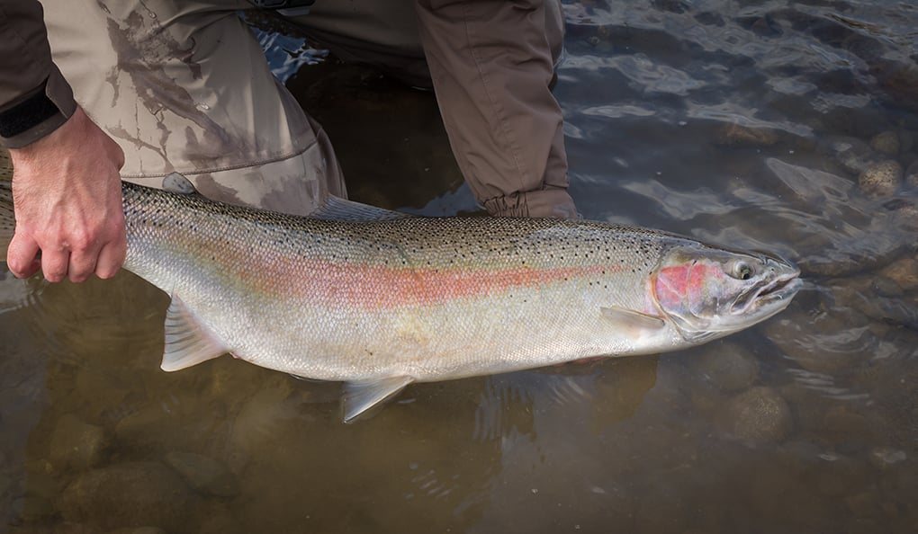
Drought conditions in 2024 hindered the start of the annual steelhead migration in Ohio. Anglers found fall-run fish staging along the Lake Erie shoreline more than they did moving upstream in the rivers.
The rains finally came, the water soaked in the ground, without affecting the river levels as normally seen. It wasn’t until after Christmas when rains filled the rivers.
A welcomed relief, the water rising, but tough conditions. It is safer to go wading after the flow peaks and the turbid water begins to clear. The catching becomes easier, too.
A flow of 100 to 200 cubic feet per second (cfs) makes for comfortable wading. From 200 to 300 cfs, wading gets tricky for the less experienced. Flow above 350 cfs is best done by the sure-footed, with felt soles or cleats on their boots. Above 600 cfs may not be a good idea.
Now that the rivers are up and so are the steelhead, here are the destinations for anglers wanting a winter adventure.
Vermillion River
The Vermillion River flows through Erie and Lorain counties.
Eight access points can be found near the mouth at the municipal boat ramp, and ending at the Wakeman dam. The stream bed is slick in places. Boots providing good traction recommended at any level. Flow (discharge) can be checked at USGS 04199500.
MORE COVERAGE FROM OHIO OUTDOOR NEWS:
Steelhead fishing going fairly strong right now on Ohio’s Lake Erie tributaries
Egypt Valley Wildlife Area parcels get nominated in Ohio drilling plan
Simple approach lands angler the new record Ohio white crappie
Rocky River
Located in Cuyahoga County, the Rocky River has 13 access points, starting near the mouth at Emerald Necklace Marina and extending to the Lagoon dam. See USGS 04201500 for river conditions.
The West Branch of the Rocky River enters below the Lagoon dam. This branch can be a trip-saver when the main river is muddy; USGS 04201400.
Cuyahoga River
Flowing through Cuyahoga Valley National Park, the Cuyahoga River is an overlooked opportunity in Cuyahoga and Summit counties. Try the State Route 82 dam in Brecksville.
Another option is in the Summit County Metroparks system, the section from Gorge Park to the Edison dam. You will find it north of Akron and west of State Route 8, between routes 261 and 59; USGS 04206425.
Chagrin River
The Chagrin River offers eight access points from the Eastlake Seawall to the South Chagrin Reservation. A state scenic river draining portions of Portage, Geauga, Lake, and Cuyahoga counties, the water runs clear when it levels off; USGS 04209000.
Grand River
Located in Lake and Ashtabula counties, the Grand is a state wild and scenic river with 10 access points, starting at the mouth up to the Harpersfield dam. Having buffered some of the effects of urbanization, it reflects what a natural stream in Ohio can be; USGS 04212100.
Arcola Creek
There are three creeks on the northern border of Lake and Ashtabula counties, Arcola, Wheeler, and Cowles. Access points are near the mouth of each stream. Start at the beach and estuary pond area on Arcola, if not familiar with the area. No river data available on these three.
Conneaut Creek
Conneaut Creek is a state wild and scenic river. Located in Ashtabula County, the headwater begins in Pennsylvania. Four access points span from the breakwall and harbor to Lakeville Park. The harbor can be a raw, windy place in the winter with lots of lake-effect snow when the rest of the state has little to none; USGS 04213000 for conditions.
Ashtabula River
The Ashtabula is aslso a state wild and scenic river with three access points from the harbor to Indian Trail Park. Anglers prefer the section from the harbor to the Smolen-Gulf covered bridge on State Route 84. No river data available; anglers can gain a rough idea of what is going on through the Conneaut station (USGS 04213000).
Tactics
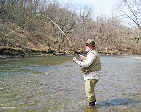
If there is a constant in steelhead fishing, it is the presentation – preferably one drifted at or near the bottom. That is the most important tactic.
Adjusting the bobber depth is necessary to cover the varied bottom; sometimes more weight is needed. Fine tune the presentation before worrying about finding the ideal fly pattern, lure color, or bait.
If still learning about steelhead, pick a river closer to you, to have more time in the water. Driving to a distant river with a reputation may not prove more fruitful.
Your day on a river is often determined by the weather conditions, including the previous couple of days’ weather. Anglers prefer two to three days of stable weather. Those accompanied by a warm front is a plus in the winter. The temperature affects the mood of the fish. The water level governs their location.
River knowledge is the secret to catching them.
Illinois bill updating trapping language awaits a signature
Illinois lawmakers have approved legislation that would modernize portions of the state’s trapping regulations, bringing Illinois more in line with
Long dismissed as ‘rough’ fish, drum are praised in new research for consuming invasive mussels
A native fish long dismissed by Illinois anglers as a “rough fish” may be playing a much larger role in

Illinois Mixed Bag: Fishing Clinics Set at Oakhurst Forest Preserve
Offered in partnership with DNR’s Urban and Community Fishing Program, the free clinics will teach participants basic angling skills, including
