


How humans read and view modern maps is one of the biggest advancements when it comes to changes in the world of hunting.
For most, long gone are the days of looking over a physical map. GPS units had their moment, but now utilizing digital maps at home on a laptop, or through an app on a smartphone while in the field, has become the preferred route for many.
Hunters can get private landowner information, set waypoints and tracks, see slope angles and toggle between 2D and 3D imagery to examine how terrain sets up, download maps on their phone to use in areas of no cell reception, and clearly see private and public land boundaries.
It does not replace what a hunter can learn from boots-on-the-ground scouting, but digital mapping apps certainly provide a great starting point. They also help hunters go safely and confidently into areas where they might have otherwise been apprehensive to go.
“It’s putting your boots on the right ground versus just putting your boots on ground,” said Jared Larsen, a whitetail and turkey marketing manager with onX – one of the early leaders in the digital mapping space. “It’s empowering an end user. Imagine an adult-onset hunter who has never had anybody show them the ropes. I can’t imagine trying to take to the woods without an app like onX and nobody there to mentor you.”
MORE HUNTING FEATURES FROM OUTDOOR NEWS:
Hunting a whitetails’ security cover: Here are keys to consistent success
Want to take the plunge into buying land for deer hunting? Here’s three things to know
Dean Bortz: OK, let’s try this archery elk hunting thing one more time
First things first
Larsen grew up in Wisconsin hunting whitetails, turkeys, and waterfowl. He currently lives in Montana and hunts many different landscapes that include chasing mule deer and elk.
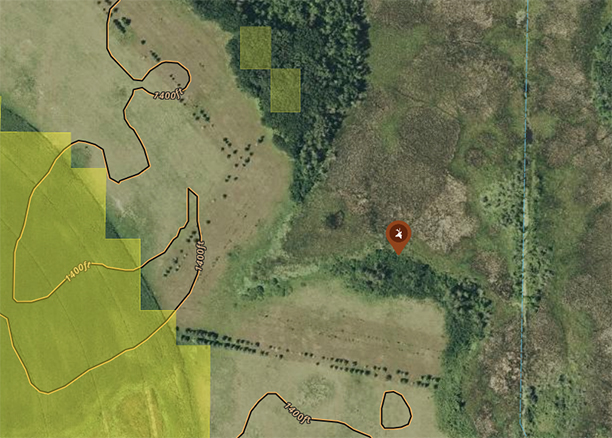
The first thing Larsen does when map-scouting for a hunt is look for specific terrain features. When it comes to whitetails, that often means finding a creek or river system.
“It’s about understanding what areas I’ve had success with in the past and how I can use that knowledge and apply that to a new place by simply finding those terrain types, those vegetation types, those outside influences (such as roads or potential hunting pressure) and using that to my advantage,” Larsen said.
Finding diversity
Once an area is identified at a broad scale, it’s about zooming in to find where to begin your search with boots-on-the-ground scouting.
Hunters understand that almost all wildlife they pursue gravitate toward areas of habitat diversity – those areas where different habitat types meet create edge and also usually offer what animals need in the form of food, water, and security.
So how do you pinpoint the more subtle habitat changes?
“What I’m looking for is color changes on the map,” Larsen said. “If you’re looking at aerial imagery, you can often see a nuanced variance of green between something like a swamp edge that still has some trees and then a couple feet higher ground that’s all deciduous cover.”
Hunters can use “layers” on digital mapping apps that make identifying these habitat edges even easier. The “Trees, Crops & Soil” folder on onX allows users to turn on and off layers that highlight the map with different colors showing features such as acorn-producing oaks, wetlands, thermal deer cover, historic wildfire, and deciduous versus coniferous tree species.
“Look for color changes on the aerial imagery and then use some of the in-depth layers to further suss out those different species of habitat, whether it’s swamps, pines, deciduous trees,” Larsen said. “I think people get caught up in words like edge, or transition areas or habitat diversity and they’re looking for this painted mosaic of different things. It’s way simpler than that. Where are two things that look different on a map and where do they meet? Start there.”

Understand the species you’re hunting
Part of best utilizing maps comes down to understanding the species you’re targeting.
Larsen says that turkeys are one of the easier animals to e-scout for, although he admits they have run him through the ringer plenty of times.
“If you can find water in close proximity to another edge, I often am confident I’ll be able to find turkeys there,” he said. “If that’s a coniferous and deciduous edge and it has an awesome creek drainage, there’s probably turkeys there. If there’s some type of drainage where it’s all deciduous but then there’s ag fields in close proximity, there’s probably turkeys there.”
For whitetails, three habitat types coming together tends to be a magic number.
“It’s food, water, and cover. If I can find a swampy area that has trees I can get in near obvious food, that’s super interesting to me,” Larsen said. “I think more common in (big woods) is finding really small diversity in large tracts of monotony. In places like northern Wisconsin and northern Minnesota, you look at a map and think that’s just a sea of trees, but if you analyze a little further you can often find a couple of ponds in close proximity, or maybe it’s a pocket of pines in a sea of deciduous cover.”
A deer’s access to food, water, and cover can all change depending on the time of year, so it’s important to take into account what part of the season you’re hunting when examining a map.
Going to the next level: 3D imagery
Hunters can certainly get by with just utilizing the basics of digital mapping apps.
Setting a waypoint at a stand location is all the further some may want to take it, but there’s much more to be had from these apps.
The exaggerated 3D imagery on onX allows hunters to see how a landscape lays out even in areas with limited topography. Whitetails, for instance, will use elevated knobs or points in many landscapes to bed as a way to see longer distances.
“In places like central Minnesota in my experience, there’s not a lot of topography change in general. If you can find 20 feet of elevation difference, that’s pretty significant,” Larsen said. “If you have a little bit of understanding that thermals are going to be falling in the morning until that sun gets up and starts bringing those thermals up the hill, you can use 3D exaggeration to really play out those thermals, understand how those deer might be bedding, and then how are they going to travel out of that bed.”

Slope angle
In addition to 3D exaggeration, the “slope angle” layer in the “Land & Access” folder in onX makes it easy to see how a landscape lays out with a color-coded radiant. This means the ability to quickly find pinch points, benches, and travel routes on the path of least resistance.
“No deer wants to walk on the purple or red. You don’t either,” Larsen said of the colors that indicate the steepest areas on the map. “So find the areas that transition around those particular terrain features and that’s a great starting point.”

Waypoint features
Hunters can set optimal wind directions on waypoints that make it clear which locations are right for the current conditions.
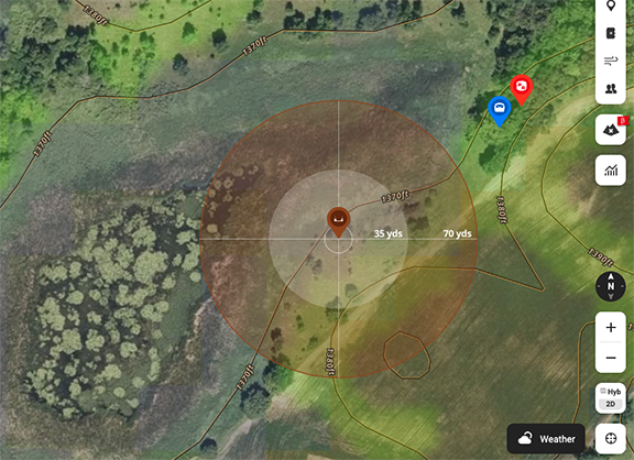
Larsen also frequently uses the radius tool for individual waypoints. This feature allows him to clearly see how close he is to specific areas he’s targeting that he found while scouting.
“I use it all the time by marking where I find a buck bed and then using that radius tool to say, ‘OK, 80 yards in a circle around this bedding area is how close I need to be,’” Larsen said. “Simply having that visual helps you be more thoughtful about where you’re going to hunt.”
Many of these features are going one step beyond how many hunters are already using their digital maps. But when fully utilized, it can add up to a better hunting experience.
“They can really help paint the picture and keep the details at the forefront of your mind,” Larsen said. “I think most folks have the right idea and the right plan. It’s usually just a detail or two that slips through the cracks.”

Steve Carney: Break out the crawlers and leeches
The month of June is the best month of fishing of the season in Minnesota. Well, this hasn’t been the

Maple Lake walleyes lead strong mixed-bag fishery in Minnesota’s Polk County
Located in Polk County, Maple Lake is the westernmost lake with any real significant fishing opportunities in northwest Minnesota’s Red
Minnesota’s Outdoor Calendar
A look at upcoming outdoors-related events from across Minnesota published in the June 26, 2026 edition of Outdoor News.
