


Story and photos courtesy of Cedar River Watershed District
Austin, Minn. — After more than a decade in the works, a major access has opened for the public on the Cedar River State Water Trail, about five miles south of Austin, Minn.
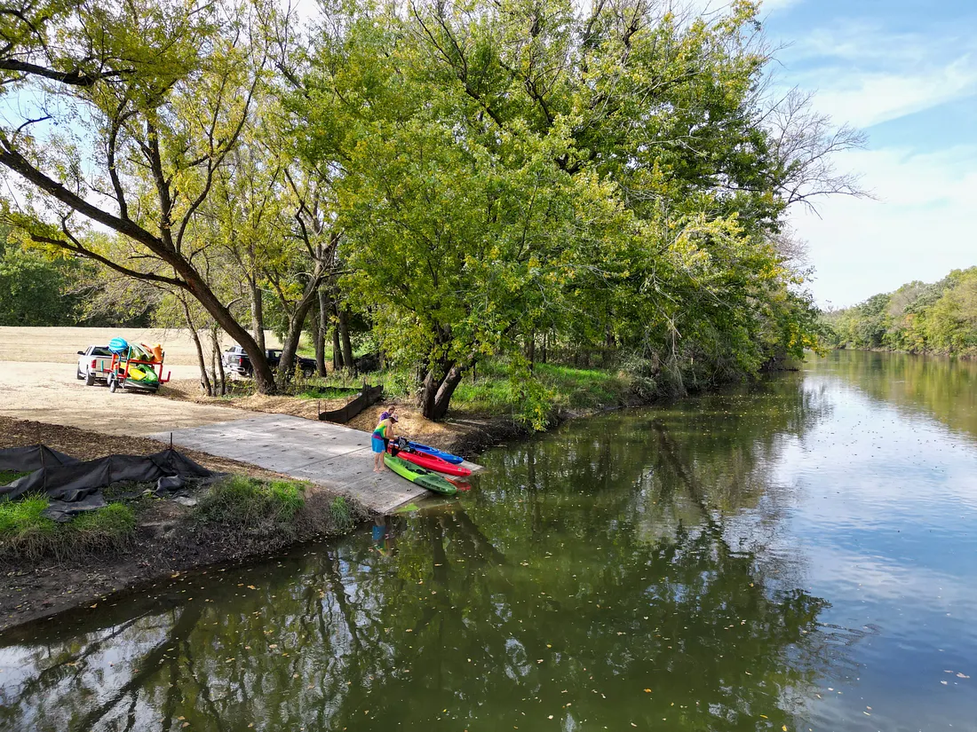
Paddlers now can exit or launch onto the Cedar River after crews removed a construction-related silt curtain last week from the water below the new concrete ramp. This 3-acre site off Minnesota Highway 105 in Lyle Township also can be enjoyed by anglers and nature enthusiasts, and it features off-road parking stalls.
On Sept. 29, state and local officials with the project gathered at the Orchard Creek Landing to view the nearly $161,000 project. This came together under a partnership of the Cedar River Watershed District, Mower Soil & Water Conservation District, Mower County, The Hormel Foundation, Minnesota Department of Transportation (the site’s owner) and the Minnesota Department of Natural Resources, which will maintain the access.
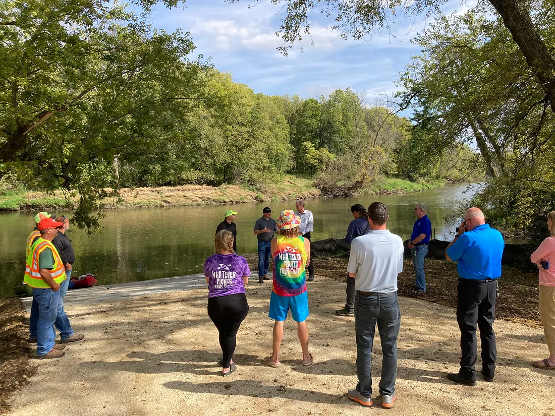
“We couldn’t be more excited for this access to finally be a reality at a beautiful stretch of the river,” CRWD outreach coordinator Tim Ruzek said. “This is a much-needed access on the Cedar River State Water Trail and a great example of the power of partnerships as we needed each other to work through challenges and get it done.”
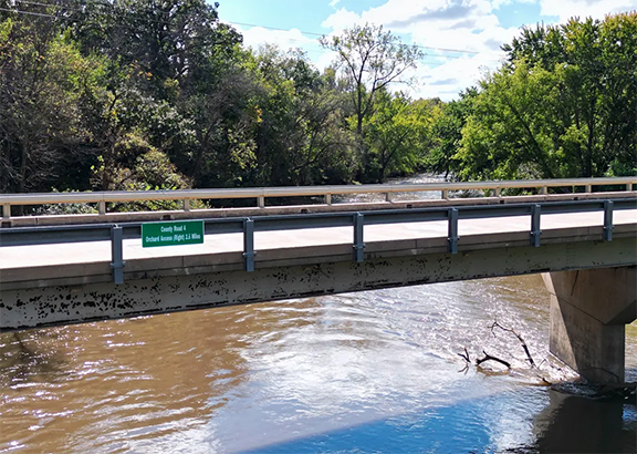
Also last week, Mower County Public Works installed signage on bridges over the Cedar River State Water Trail south of Austin to the Iowa border. This included County Roads 28, 4, 5, 6 and Stateline Road. The county created and installed the signs at the request of CRWD, which covered the costs.
These signs identify the bridge and include details on the next access downstream. They were inspired by similar bridge signage over the Cedar River in neighboring Mitchell County, Iowa, which made the Cedar an official “water trail” in 2023.
MORE COVERAGE FROM MINNESOTA OUTDOOR NEWS:
Beating the heat, bugs for a Minnesota doe on the bow opener
A look back: Noteworthy observations from four decades examining Minnesota lakes
Minnesota’s bear harvest likely to reach about 2,500 – an average year, DNR says
Charity Lifka, of Austin, discovered a passion for kayaking in 2020 and has kayaked the local stretch of the Cedar seven times this season, seeking the relaxation and wildlife offered by the river. She used the new Orchard Creek Landing over the weekend, launching at the DNR’s Riverwood Landing in Austin Township.
“The parking lot is amazing and the access is perfect — it was very easy and convenient to get out,” Lifka said, adding she and husband also appreciate the new bridge signage. “I feel like having this new access will make it easier for more people to enjoy the beautiful river and kayaking — I know it’s going to encourage us to kayak even more often.”
CRWD had pursued the Orchard access since 2014 but challenges with funding and the site’s land records delayed progress. A big component of the project was building a larger, safer vehicle entrance/exit to the site off Highway 105.
Located between Mower County Roads 4 and 5, the Orchard access is about a half mile south of the Cedar City Cemetery sign along Highway 105. DNR water-access signs are posted on Highway 105 for north- and southbound traffic.
“The Minnesota Department of Transportation is pleased to be part of a project that engages all partners to achieve a positive outcome for the public and meets the needs of all involved,” said Mike Dougherty, a spokesman for MnDOT District 6 in southeast Minnesota.
Overall, the project was funded by a $44,000 design-only DNR grant and $95,000 grant from The Hormel Foundation, with the rest covered by federal American Rescue Plan Act (ARPA) funds provided by Mower County to Mower SWCD.
Rochester Sand & Gravel built the access designed by Les Conway of the WSE Massey engineering firm.
Silt curtains on the land remain in place until vegetation gets established. Signage related to the state water trail is planned near the access along with the installation of a solar-powered light. DNR maps for the Cedar River State Water Trail will be updated for the 2026 season to include the Orchard Creek Landing.
For paddlers, the Orchard access is about 7.5 river miles downstream from the public canoe-kayak launch behind Austin’s Marcusen Park baseball stadium. It’s nearly 4 river miles south of the DNR’s Riverwood Landing in Austin Township.
From Orchard, it’s about 8 river miles to Stateline Road, where a small access is on the Iowa side.
This landing at Orchard Creek is the fifth public access built since 2017 by CRWD-Mower SWCD and partners on the Cedar River State Water Trail and its tributary streams of Turtle and Wolf creeks. While paddlers can put in and take out at county bridges, those sites can be difficult for launching or taking out watercraft due to large rocks protecting the bridges.
Totaling 25 river miles in Mower County, the Cedar River State Water Trail is one of 35 state water trails that cover more than 4,500 miles. In 2011, the Minnesota Legislature designated this stretch of the Cedar (village of Lansing to the Iowa border) as the 33rd state water trail at the request of CRWD and its partners.
In 2023, state and county officials in Iowa celebrated designating 32 miles of the Cedar River as a “state water trail” through Mitchell County, which borders Mower County. That created 57 continuous river miles of “state water trail” between Mower and Mitchell counties. CRWD continues to work with colleagues in Iowa on water trail projects.
For more on Minnesota’s Cedar River State Water Trail, go online at: www.dnr.state.mn.us/watertrails/cedarriver
New York’s Outdoor Calendar
A look at upcoming outdoor-related events from across New York published in the June 26, 2026 edition of Outdoor News.

New York Cuffs & Collars: Turkey rescued and released in Saratoga County
New York cuffs and collars are field reports from DEC Officers. These reports are from the June 26, 2026 edition
Former NRA leader, LaPierre, loses appeal
Former National Rifle Association Executive Vice President Wayne LaPierre will have to pay $4.3 million back to the organization after
